Why Liberia?
Liberia’s Harper Basin has a geological history and petroleum system similar to Ghana, Côte d’Ivoire, and Guyana, which have seen recent oil discoveries. Success in exploration along the northern South American coast has highlighted the potential for offshore Liberia whose coastline can be tectonically reconstructed to fit with the Guyana Basin, suggesting a similar prospect.
The shelf area features typical syn-rift structures with growth sequences sourced from quartz-rich sediments eroded from onshore Precambrian outcrops. During the transition from syn-rift to drift in the Albian period, renewed erosion relocated some reservoir material to the slope, now pinching out against the basin-binding fault. This creates promising leads along the basin as these materials brighten into the up-dip trap.
Liberia Direct Negotiation Licensing Round 2024
The Government of Liberia, through the Liberia Petroleum Regulatory Authority (LPRA), has launched a Direct Negotiation Licensing Round comprising 29 offshore blocks. This initiative aims to award licenses to boost exploration and production investments in the Liberia and Harper Basins. Overseen by the LPRA and in line with the amended E&P law of 2019, this licensing round ensures transparency and competitiveness
Liberia’s fiscal terms are designed to achieve stability, transparency, and investor-friendly policies and to set a clear framework through the Model Production Sharing Contract (PSC). Block applications will be processed on a first-come, first-served basis following the prescribed five (5) phrase process from – Submission of indications of interest in particular blocks to Executed PSCs.
Links to 2024 Licensing Round Application Documents.
You can use the links below to download all five documents:
The “2024 Invitation to Participate Documents” link includes:
- Blocks on Offer and Availability Data
- 2024 Operator Prequalification Eligibility Requirements
- 2024 Local Company Prequalification Eligibility Requirements
- 2024 Liberia Licensing Round: Invitation to Participate
The “Liberia Model PSC” link contains the Liberia Model Production Sharing Contract (PSC).
Liberia Exploration Potential
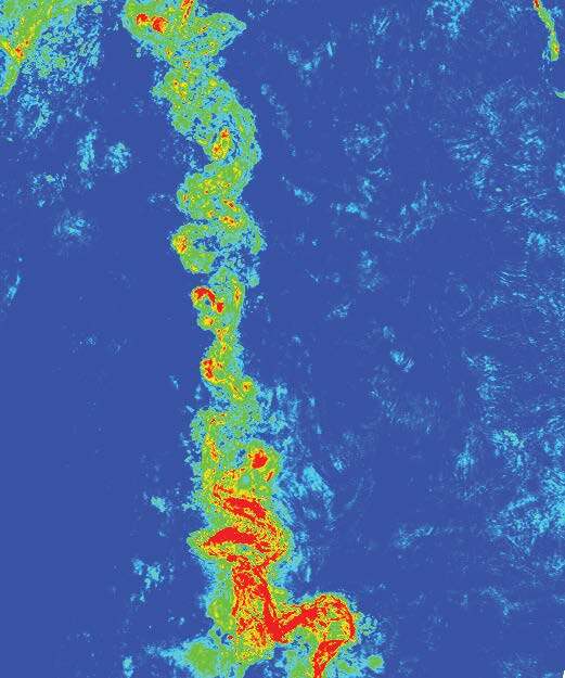
Liberia boats strong play diversity from the syn-rift Lower Cretaceous to the deepwater Upper Cretaceous with multiple source rock intervals across the stratigraphy. The range of multi-client data available: 2D seismic, 3D seismic, and gravity and magnetic data, together with the well data, allows for a robust understanding of the plays and numerous prospects and leads are identifiable. Since 2023, TGS has undergone reprocessing of the “Block 8&9 3D” and part of the 2D surveys (primarily within the Liberia Basin). This has improved imaging quality, velocity modeling and amplitude, and AVO confidence, de-risking certain prospects and improving trap and structural certainty.
Modeling predicts that the source rock maturity and expulsion post-dates the main tectonism in the basin. In contrast, rock data supports the presence of effective seal horizons, comparable with West African Transform Margin analogs. Volumetric assessment of leads suggests that field sizes with over a billion barrels of oil in place could be present through various stratigraphic and structural trapping mechanisms.
- 33 offshore blocks ranging from 2300 to 3500 km2
- 17 exploration wells drilled in both shelf and deepwater domains
- Proven petroleum system in the Cretaceous plays
Data Availability
| Block | Block Area (KM2) | Water Depth (m) Min | Water Depth (m)Max | Total 3D Seismic Data Coverage (KM2) | Total 2D Seismic Data Coverage (KM) |
|---|---|---|---|---|---|
| LB-01 | 2996 | 10 | 3000 | 1760 | 677 |
| LB-02 | 3431 | 10 | 2400 | 1491 | 499 |
| LB-03 | 3274 | 10 | 2100 | 651 | 253 |
| LB-04 | 2986 | 10 | 1200 | 425 | 170 |
| LB-05 | 3187 | 10 | 1400 | 844 | 235 |
| LB-06 | 3001 | 10 | 900 | 128 | 409 |
| LB-07 | 2935 | 2000 | 3400 | 1612 | 971 |
| LB-08 | 3419 | 700 | 3400 | 2711 | 1113 |
| LB-09 | 3117 | 200 | 3300 | 2930 | 1056 |
| LB-10 | 3025 | 100 | 3000 | 2802 | 990 |
| LB-11 | 3023 | 100 | 2500 | 2687 | 861 |
| LB-12 | 2811 | 2500 | 4000 | 214 | 817 |
| LB-13 | 3088 | 3200 | 3900 | 0 | 888 |
| LB-14 | 2981 | 3100 | 3800 | 0 | 859 |
| LB-15* | 3247 | 2400 | 3600 | 166 | 975 |
| LB-16* | 3134 | 1700 | 3300 | 1865 | 1006 |
| LB-17 | 3276 | 1100 | 4300 | 418 | 821 |
| LB-18 | 3368 | 3600 | 4100 | 0 | 633 |
| LB-19 | 3404 | 3700 | 4000 | 0 | 949 |
| LB-20 | 3072 | 3700 | 4000 | 0 | 851 |
| LB-21 | 2205 | 3800 | 4100 | 0 | 534 |
| LB-22* | 3301 | 3100 | 3700 | 0 | 969 |
| LB-23 | 3293 | 3000 | 4500 | 0 | 892 |
| LB-24* | 3314 | 2800 | 4200 | 0 | 913 |
| LB-25 | 2445 | 10 | 1400 | 186 | 366 |
| LB-26 | 2482 | 10 | 2500 | 525 | 464 |
| LB-27 | 2300 | 10 | 2500 | 525 | 464 |
| LB-28 | 2256 | 10 | 2900 | 0 | 407 |
| LB-29 | 3272 | 300 | 4300 | 0 | 971 |
| LB-30 | 3391 | 1000 | 4100 | 1547 | 1001 |
| LB-31 | 3051 | 2500 | 4200 | 2250 | 876 |
| LB-32 | 2322 | 1500 | 4200 | 656 | 753 |
| LB-33 | 2332 | 1500 | 4200 | 0 | 661 |
Liberia Exploration Potential
In 2022, Our partner TGS reprocessed over 5,100 km² of key 3D seismic data covering the northeast region of the Liberia Basin using a Pre-Stack Depth Migration (PSDM) workflow. This advanced technique optimizes the imaging of main targets in the Cretaceous reservoirs, offering the latest insights into the area’s prospectivity.
2D:
- PSTM = 24,772 km
- PSDM = 24,772 km
- Reprocessed = 12,214 km
3D:
- PSTM = 18,342 km2
- PSDM = 15,329 km2
- PSTM/PSDM (for Block 10 and Sunfish 3D, combined Time and Depth figure) = 8,582 km2
- Repro = 5,142 km2
Gravity:
- 2D = 24,772km
- 3D = 6,597sqkm
For Further Negotiation Inquiries
For further information regarding the negotiations, we encourage you to contact the LPRA at info@lpra.gov.lr or +231 77 711 0110 (available Monday-Friday, 9 a.m. – 4 p.m. GMT). For information on the exclusive TGS data available across these basins for the assessment of exploration opportunities, please TGS.
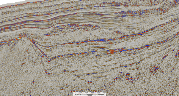
Liberia's Geology
BSR (bottom simulation reflector) and OPAL boundaries (both chemical and mineralogical phenomena) were identified in the modern Sunfish 3D seismic survey and were used in the basin modeling to tie source rock (SR) maturation phase, pore pressure, and burial basin temperature in the system. Models of various locations throughout the basin reveal that oil and gas have likely been generated and continue to be in active kitchens at present, with the Albian SR in the gas window and the well-extended Turonian-Cenomanian interval in the oil window. Their hydrocarbon generation timing is favorable for the stacked slope channel systems in the Late Cretaceous system, sealed by backfilling muds.